Seite 1 von 1
25.07.2023 Schauer- und Gewitterthread
Verfasst: Dienstag 25. Juli 2023, 06:59
von nuntius
Auf was gestern teils gewartet wurde, kommt heute früher als gedacht.
Re: 25.07.2023 Schauer- und Gewitterthread
Verfasst: Dienstag 25. Juli 2023, 07:36
von chris-kapfenberg
Nach kurzem Sonnenschein ganz in der Früh zieht nun aus SW ein erstes Gewitter auf.
Temp. akt. 16,5°.
LG, chris-kapfenberg
Re: 25.07.2023 Schauer- und Gewitterthread
Verfasst: Dienstag 25. Juli 2023, 07:42
von nuntius
Über Italien entwickelt sich aktuell eine mächtige Zelle, mit Zugrichtung Slowenien. Mit der heutigen Südwest-Strömung wird besonders der Süden und Südosten von Gewittern betroffen sein. Da sich zudem hier noch energiereiche Luftmassen befinden, können diese durchaus kräftig ausfallen.
Re: 25.07.2023 Schauer- und Gewitterthread
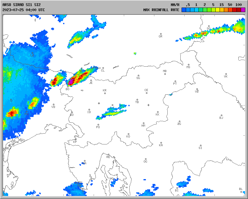
Verfasst: Dienstag 25. Juli 2023, 08:03
von hhkes
Ein wirklich gewaltiger Gewittercluster (ARSO-NS-Radar):

LG, Harald
Re: 25.07.2023 Schauer- und Gewitterthread
Verfasst: Dienstag 25. Juli 2023, 08:44
von nuntius
Die Gewittern treffen nun das Südburgenland. Besonders ist aber auf den Left-Mover? mit Zugrichtung Graz zu achten!
Re: 25.07.2023 Schauer- und Gewitterthread
Verfasst: Dienstag 25. Juli 2023, 08:48
von nuntius
Heutige Forecast von estofex
Storm Forecast
Valid: Tue 25 Jul 2023 06:00 to Wed 26 Jul 2023 06:00 UTC
Issued: Tue 25 Jul 2023 06:23
Forecaster: PUCIK
A level 3 was issued across Slovenia, N Croatia, S Hungary and W Romania mainly for damaging wind gusts, very large hail and to the lesser extent for tornadoes.
A level 2 was issued across N Italy mainly for very large hail, severe wind gusts and tornadoes. A strong tornado threat will be present along the Apennines!
*** Severe weather outbreak continues with the threat shifting further east during the day! ***
DISCUSSION
... Slovenia, N Croatia, S Hungary, NW Romania ...
A band of intense storms has entered Slovenia from N Italy. The environment ahead is characterized by >1500 J/kg of MUCAPE combined with very strong effective shear. The storms will pose a risk of very large hail. Severe wind gusts are likely despite the fact that storms may be elevated at first. As the storms move E, daytime heating over Hungary may allow for the storms to become surface based. A development of bow echo is possible given 20+ m/s of 0-3 km shear. Extremely severe wind gusts threat will thus increase towards the later hours as the system moves towards Romania. Some forecast hodographs also show around 10 m/s of 0-1 km shear and large amounts of streamwise vorticity in the inflow to the storms. This threat will be conditional upon the convective mode and whether the surface heating will allow the cloud bases to become higher.
... N Italy ...
While the main line of storms has passed towards E, high-res models still indicate a development of more isolated storms, supercells, especially along the Apennines. Will maintain a Lvl 2. Shear profiles will remain extremely conducive for supercells capable of all hazards, but increasing dryness in mid-troposphere may inhibit the activity later on. A tornado risk will be present especially along the W flank of the Apennines, where models show 10+ m/s of 0-1 km bulk shear and 150 m2/s2 of 0-500 m SRH. If an isolated supercell moves across the region, a strong tornado risk can be expected in such an environment.
... S Germany, Alps, SW Czechia ...
Ahead of the approaching short-wave trough, along the front, scattered to widespread storms are forecast to form, in the environment of MLCAPE up to 1000 J/kg and 0-6 km shear of around 15 m/s. Expect risks of large hail and isolated severe wind gusts from stronger storms, couple of which could be supercells.
 3258 mal betrachtet")
Re: 25.07.2023 Schauer- und Gewitterthread
Verfasst: Dienstag 25. Juli 2023, 09:06
von sindarella
hier ein nettes gewitter
relativ blitzintensiv - und lautes gedonnere
es regnet so daher
kein wind
und es ist endl mal angenehm kühl
wenn nicht noch irgendwas böses nachkommt einfach eine wohltat
Re: 25.07.2023 Schauer- und Gewitterthread
Verfasst: Dienstag 25. Juli 2023, 09:20
von jfk
Diese heftige "Left-Mover-Superzelle" über SG bis in die Weststeiermark hat im Raum Eibiswald anscheind für größeren Hagel gesorgt.
Radar:

Nun heftig in SLO:

Quelle: Radarska Slika Padavin (
https://meteo.arso.gov.si/met/sl/weather/observ/radar/)
Hier im Mürztal mäßiger Regen mit kräftigen (wsl positiven) GCs alle 5-10 Minuten.

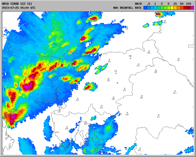
Re: 25.07.2023 Schauer- und Gewitterthread
Verfasst: Dienstag 25. Juli 2023, 09:32
von Feli
hier landregen fast ohne wind und hin und wieder ein paar blitze und donner - richtig gemütlich - so mag ich sommerregenwetter!

takt. = tmin. 15,9°C
Re: 25.07.2023 Schauer- und Gewitterthread
Verfasst: Dienstag 25. Juli 2023, 10:28
von jfk
Hier die abziehende Linie:

Quelle: Radarska Slika Padavin (
https://meteo.arso.gov.si/met/sl/weather/observ/radar/)
TAWES Bad Radkersburg mit 95 km/h Böe um 09:50 Uhr

Re: 25.07.2023 Schauer- und Gewitterthread
Verfasst: Dienstag 25. Juli 2023, 11:00
von jfk
Und die nächste Welle rollt auf den Süden zu:

Quelle: Radarska Slika Padavin (
https://meteo.arso.gov.si/met/sl/weather/observ/radar/)
Re: 25.07.2023 Schauer- und Gewitterthread
Verfasst: Dienstag 25. Juli 2023, 12:07
von Feli
ORF-steiermark: 2.500 haushalte nach untwetter ohne strom
https://steiermark.orf.at/stories/3217319/
ORF-kärnten: gewitterfront mit starkregen in der früh
https://kaernten.orf.at/stories/3217274/
hagelschlag am dienstagfrüh in feldkirchen
quelle: günther walcher

überschwemmung in st. andrä im lavanttal
quelle: georg bachhiesl

Re: 25.07.2023 Schauer- und Gewitterthread
Verfasst: Dienstag 25. Juli 2023, 12:55
von jfk
Re: 25.07.2023 Schauer- und Gewitterthread
Verfasst: Dienstag 25. Juli 2023, 18:47
von jfk
4. Welle inkl. langlebiger Superzelle am Südrand:

Quelle: Radarska Slika Padavin (
https://meteo.arso.gov.si/met/sl/weather/observ/radar/)
Re: 25.07.2023 Schauer- und Gewitterthread
Verfasst: Dienstag 25. Juli 2023, 18:47
von Feli
grad entdeckt bei wolfsberg in kärnten eiert schon wieder so eine heftige zelle herum - der linkeste ausschnitt vom panorama-bild
Re: 25.07.2023 Schauer- und Gewitterthread
Verfasst: Dienstag 25. Juli 2023, 19:14
von gerhard
Gewitter im N-flachgau zwischen St pantaleon und Oberndorf bei Salzburg
überraschend Blitzintensiv, am nördlichen Ende der Zelle kein Hagel, wuerde aber Hagel im Zentrum nicht ausschließen
Re: 25.07.2023 Schauer- und Gewitterthread
Verfasst: Dienstag 25. Juli 2023, 20:04
von Feli
zieht schon so lang ostwärts und ist noch immer so "schön" geformt... hier bei straden in der südoststeiermark
Re: 25.07.2023 Schauer- und Gewitterthread
Verfasst: Dienstag 25. Juli 2023, 20:27
von Feli
und weils so "schön" ist, zieht jetzt noch eine zelle direkt die gleiche linie wie vorher...

die drau ist eine einzige braune brühe, wie ich auf einer webcam sehen konnte... auch kein wunder...
Re: 25.07.2023 Schauer- und Gewitterthread
Verfasst: Dienstag 25. Juli 2023, 21:17
von Feli
jetzt ist hier ein minischauer mit viel wind und kurz viel regen durchgezogen - hätt ich nicht gedacht
Re: 25.07.2023 Schauer- und Gewitterthread
Verfasst: Dienstag 25. Juli 2023, 23:12
von hhkes
Feli hat geschrieben: ↑Dienstag 25. Juli 2023, 20:04
zieht schon so lang ostwärts und ist noch immer so "schön" geformt...
Wir waren dran (bei St. Veit/Vogau). Hier 2 Bilder als "Vorgeschmack" zum Bericht:


LG, Harald
