
Schwere sturmböen im 13
Platzregen
10.08.2017 Schauer u. Gewitterthread
Forumsregeln
Bitte im Titel Datum (DD.MM.YYYY) angeben.
Bitte im Titel Datum (DD.MM.YYYY) angeben.
-
marcus_wien

- Beiträge: 12337
- Registriert: Dienstag 21. April 2009, 18:30
- Wohnort: wien2
marcus_wien2 165üNN, temp Messung: 2 m über Rasen in ca 800m² grossen begrünten Innenhof - in Wien2 nähe Nestroyplatz
Sturmböen sind im 2. angekommen, es weht ein fast schon heißer Wind aus der Richtung der Zelle. Es beginnt gerade waagerecht zu regnen.
Einige Blitze, soeben CC und CG gleichzeitig.
Einige Blitze, soeben CC und CG gleichzeitig.
Zuletzt geändert von Nyuli am Donnerstag 10. August 2017, 16:02, insgesamt 1-mal geändert.
-----------------
Gruß, Stefan
Gruß, Stefan

Hier krätiger Regen und Windböen. Kein Hagel. Nichts tragisches. Dürfte etwas weiter westlich heftiger gewesen sein.
-
ThomasPf

- Beiträge: 8169
- Registriert: Mittwoch 27. März 2013, 15:50
- Wohnort: Hart bei Graz/ Ragnitztal
Lt. AC-Radar lässt die Zelle generell Richtung Wien jetzt nach. Die Zelle in der Bucklingen Welt schaut gefährlicher aus.
Liebe Grüße,
Thomas.
Hart bei Graz, Ragnitztal 47°4'25''N, 15°31'1''E, 418m ü.NN, bzw.
Graz Innere Stadt 47°04'12''N, 15°26'26''E, 353m ü.NN
Meine Fotoalben
Thomas.
Hart bei Graz, Ragnitztal 47°4'25''N, 15°31'1''E, 418m ü.NN, bzw.
Graz Innere Stadt 47°04'12''N, 15°26'26''E, 353m ü.NN
Meine Fotoalben
Ja. Wobei - wie gesagt - etwas westlich von hier (Richtung Purkersdorf) tut sich mehr.ThomasPf hat geschrieben:Lt. AC-Radar lässt die Zelle generell Richtung Wien jetzt nach. Die Zelle in der Bucklingen Welt schaut gefährlicher aus.
Ja, was Wien anbelangt, die Zelle verhungert... kann nicht wahr sein.ThomasPf hat geschrieben:Lt. AC-Radar lässt die Zelle generell Richtung Wien jetzt nach. Die Zelle in der Bucklingen Welt schaut gefährlicher aus.
Es donnert weiter fleißig aber leise vor sich hin, der Niederschlag ist aber nur mäßig, Wind gibt´s, aber nix besonderes, es gab 5-10 Sekunden lang Hagel mit 5mm.
Insgesamt enttäuschend.
EDIT: Richtung S wird schon heller...
-----------------
Gruß, Stefan
Gruß, Stefan
-
Tomscout
Zieht alles relativ schnell durch. Stationär war zum Glück bei uns nichts.
Man darf gespannt bleiben wie es weitergeht, da über dem Raum Triest über der kompletten ADRIA sich einiges tut und wenn die Verhältnisse so bleiben, in weiterer Folge es zu uns zieht (kann, könnte?)
Man darf gespannt bleiben wie es weitergeht, da über dem Raum Triest über der kompletten ADRIA sich einiges tut und wenn die Verhältnisse so bleiben, in weiterer Folge es zu uns zieht (kann, könnte?)
-
steirerbua

- Beiträge: 2261
- Registriert: Montag 20. April 2009, 11:14
- Wohnort: Wagenbach bei Ebersdorf 8273(Bez.Hartberg)
- Kontaktdaten:
...man kann schon gespannt sein auf den Gewittercluster derzeit über der oberen Adria mit Zugrichtung NO, jetzt reist es noch einige Stunden vorher auf mit viel Einstrahlung !
-
Tomscout
Rein vom Gefühl her kann es passieren, dass es sich weiter über Teile der Süd Steiermark zuspitzt aber dann die Energie Richtung Semmering wieder verliert. Möglich?
ein ausgedehnter Gewittercluster über der oberen Adria und Südtirol zieht nach Nordosten und wird in den kommenden Stunden
fast ganz Österreich überqueren.
fast ganz Österreich überqueren.
Standort: Sierning bei Steyr/O.Ö. , Seehöhe: 330 m
Wetterstation: Vantage Pro2
Web: http://www.wetter-hausruckviertel.at" onclick="window.open(this.href);return false;
Wetterstation: Vantage Pro2
Web: http://www.wetter-hausruckviertel.at" onclick="window.open(this.href);return false;
-
ManuelW4

- Beiträge: 7967
- Registriert: Sonntag 19. April 2009, 19:12
- Skype: manuel_waldviertel
- Wohnort: Oberedlitz | nördl. Waldviertel, 485 m
- Kontaktdaten:
gaaden 14 mm durch das gewitter
- Oberedlitz an der Thaya (nördl. Waldviertel, Bezirk WT), 485 m
- Allentsteig (Bezirk ZT), 535m
>>http://www.wetter-waldviertel.at
>>https://www.facebook.com/WetterWaldviertel
- Allentsteig (Bezirk ZT), 535m
>>http://www.wetter-waldviertel.at
>>https://www.facebook.com/WetterWaldviertel
ManuelW4 hat geschrieben:gaaden 14 mm durch das gewitter
bei mir wieder mal ein Rohrkrepierer, gerade mal 3mm
Lg Macs
private Wetterstation Waidhofen/Thaya - http://macs.co.at
private Wetterstation Waidhofen/Thaya - http://macs.co.at
-
Pete

- Beiträge: 1087
- Registriert: Freitag 3. Juli 2009, 14:36
- Wohnort: Waltersdorf a.d. March / NÖ / Bez. Gänserndorf
Hier vor kurzem Gewitter mit einigen heftigen Böen und Naheinschlägen sowie sage und schreibe 0,3 mm Regen!
Liebe Grüße
Peter
Wohnort: Waltersdorf a.d. March / NÖ / Bez. Gänserndorf(48,52° N 16,88° E, 160 m)
Arbeit: Wien 22
Peter
Wohnort: Waltersdorf a.d. March / NÖ / Bez. Gänserndorf(48,52° N 16,88° E, 160 m)
Arbeit: Wien 22
-
ManuelW4
- Beiträge: 7967
- Registriert: Sonntag 19. April 2009, 19:12
- Skype: manuel_waldviertel
- Wohnort: Oberedlitz | nördl. Waldviertel, 485 m
- Kontaktdaten:
im weinviertel würden sie sich über 3mm freuen.....Macs hat geschrieben:ManuelW4 hat geschrieben:gaaden 14 mm durch das gewitter
bei mir wieder mal ein Rohrkrepierer, gerade mal 3mm
- Oberedlitz an der Thaya (nördl. Waldviertel, Bezirk WT), 485 m
- Allentsteig (Bezirk ZT), 535m
>>http://www.wetter-waldviertel.at
>>https://www.facebook.com/WetterWaldviertel
- Allentsteig (Bezirk ZT), 535m
>>http://www.wetter-waldviertel.at
>>https://www.facebook.com/WetterWaldviertel
In Wien auch nur um die 2,5mm (Hohe Warte), lediglich die westlichen Bezirke haben mehr bekommen, z.B. Jubiläumswarte in Summe 7mm.Macs hat geschrieben:ManuelW4 hat geschrieben:gaaden 14 mm durch das gewitter
bei mir wieder mal ein Rohrkrepierer, gerade mal 3mm
1060&1230 Wien.
https://www.lightningmaps.org" onclick="window.open(this.href);return false; geht wieder, zumindest bei mir!
ASPANG/WECHSEL

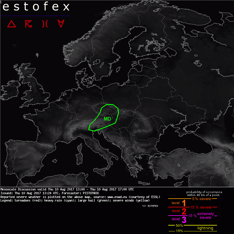
Die Fexen haben eine MD - Warnung für quasi ganz Österreich ausgegeben.
Hab gerade nur das Handy bei der Handy, keine Ahnung wie man da das Bild einfügt.
http://www.estofex.org" onclick="window.open(this.href);return false;
edit Feli - bild eingefügt:
Hab gerade nur das Handy bei der Handy, keine Ahnung wie man da das Bild einfügt.
http://www.estofex.org" onclick="window.open(this.href);return false;
edit Feli - bild eingefügt:
Hier in Linz aktuell sonnig mit ein paar kleinen Wolkenfeldern.Mesoscale Discussion
Valid: Thu 10 Aug 2017 13:00 to Thu 10 Aug 2017 17:00 UTC
Issued: Thu 10 Aug 2017 13:24
Forecaster: PISTOTNIK
Recapitulation of last night:
A remarkable outbreak of extremely severe storms occurred in the warm air advection regime over central Europe. Numerous supercells with very large hail formed over N Italy and Austria in the evening, complemented by weaker but still organized storms over SE Germany (Bavaria) and the W Czech Republic (Bohemia), where cooler air prevented surface-based activity. After midnight the storms merged into a large bow echo which caused widespread wind damages from the E Czech Republic into central Poland before it decayed in the morning.
Current situation and probable development of the next few hours:
The storm system left a long outflow boundary roughly along a line Udine (IT) - Graz - Vienna (AT) - Olomouc (CZ) - Warsaw (PL), which separates cooler air and mostly W-erly winds to the west from hot air and mostly SE-erly winds to the east. This boundary has been further sharpened by differential heating (clouds and showers to the west versus sunshine to the east) in N Italy and Austria, while plenty of sunshine and a return of warm air advection with backing winds are constantly softening it over the Czech Republic and Poland.
The pronounced temperature and moisture gradients are also reflected by the CAPE values from the 12z soundings: 0 J/kg in Germany, around 800 J/kg in Prague, Vienna and Milano, around 1500 J/Kg in Prostejov and Budapest, and up to 4000 (!) J/Kg in Udine. Station data suggest that CAPE well in excess of 2000 J/kg is probably present in NE Italy, parts of Slovenia, Croatia, W Hungary and extreme east Austria (increasingly capped towards the SE). Compared to the model forecasts, the hot air with abundant CAPE seems to be shifted about 200 km to the east.
Two foci of convective activity emerge for the next few hours:
(1) Storms originating over the Italian Alps are just crossing central Austria. They will likely stay elevated as long as they are in Austria (2m temperatures of 22-24°C in their path), but in case they survive, they would have increasing chances to become surface-based in the quickly warming conditions over the Czech Republic. This scenario is what most of the NWP models would see.
(2) The second focus for initiation is the stationary outflow boundary with its extreme temperature gradient (>10K/100km) further southeast. First storms are forming at this boundary over E Austria and should intensify as they can follow this boundary.
In general, the overlap of robust CAPE and very strong vertical wind shear (including directional shear) suggests that any storm that becomes surface-based poses a risk of severe to extreme weather events - mainly hail in case of discrete storms, mainly wind in case a convective line forms!
mfg Geri
Canon EOS 550D
Canon EOS 550D