

Auch heute besteht wieder ordentliches Unwetterpotential.
Am Nachmittag wird der Schwerpunkt von Osttirol/Oberkärnten nordwärts liegen, da könnte es in Unterkärnten noch trocken bleiben. Spätestens in der Nacht sind aber auch hier schwere Gewitter zu erwarten.
Kann leider am Handy keine Karten reinstellen.
28.06.2022 Schauer- und Gewitterthread
Forumsregeln
Bitte im Titel Datum (DD.MM.YYYY) angeben.
Bitte im Titel Datum (DD.MM.YYYY) angeben.
-
Feli

- Beiträge: 22242
- Registriert: Freitag 20. März 2009, 08:46
- Skype: felisky
- Wohnort: Aschach/Steyr
- Kontaktdaten:
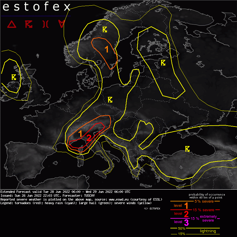
hier die estofex.org vorhersage:
Extended Forecast
Valid: Tue 28 Jun 2022 06:00 to Wed 29 Jun 2022 06:00 UTC
Issued: Sun 26 Jun 2022 22:03
Forecaster: TUSCHY
A level 2 was issued across the Ligurian Sea into parts of N Italy and S Austria/W Slovenia mainly for large to very large hail, severe wind gusts and excessive rain.
SYNOPSIS
Dominant Scandinavian blocking pattern with a 3+ sigma standardized geopotential height anomaly (79-09 climate, CFSR climatology) centered near the North Cape persists during the period with ridging extending all the way down to Italy. This ridge gets framed by a long-lived strong cyclonic vortex just W of Ireland and a quasi-stationary cut-off over Turkey. The western trough crashes into this stout ridge with rapid weakening forecast over E Europe. Still, a pronounced short wave is able to cross the Gulf of Lion before opening up into a disorganized wave, which affects N-Italy during the rest of the forecast.
Regarding synoptic-scale fronts, the main feature is the slowly eastbound crawling front in the form of a cold front from S Norway to Poland and turning more into a leisurely lifting warm front over CNTRL Europe.
Regarding NWP stability there is not much to complain about. The wave over the W/CNTRL Meditherranean is rather stable regarding speed/placement and curvature with only a marginal slow down seen in last 2 GFS runs, bringing the wave more towards ICON and IFS. IFS-ENS indicate some weak member clustering of a broad/diffuse LL depression (1015 hpa range), which crosses Corse around noon and approaches the N Adriatic Sea during the overnight hours (with an increasing meridional spread of members, gradually loosing track of any LL circulation). This trend has to be monitored regarding the southward extend of potential CI all the way into CNTRL Italy with additional LL forcing.
DISCUSSION
... Parts of N/CNTRL Italy into Slovenia/S Austria ...
With the approaching wave from the SW, lowering MSLP is forecast over NW Italy into the Ligurian Sea with E-erly LL flow pushing a moist BL towards the N Apennines and the Maritime Alps. Slight discrepancies exist with the placement of the LL thermal ridge and attendant EML which results in variable W-ward expansion of the most robust CAPE plume. Up to 2000 J/kg MLCAPE evolves along the N fringe of the Apennines with similar values towards the Adriatic Sea.
Regarding CI, ample orographic and synoptic-scale lift is forecast with a prolonged period of 20-25 m/s S-erly 700 hPa flow (less at 850 hPa). Hence, scattered to widespread CI is forecast from the start of the forecast with ample MUCAPE for elevated convection with the main risk being isolated large hail and heavy rain. This risk expands towards NE Italy until noon.
This activity may enter an increasingly uncapped airmass, when crossing Austria (800-1500 J/kg MLCAPE) with DLS increasing to 10-15 m/s, so strong to severe convection is possible over CNTRL/E Austria during the afternoon hours with this activity (hail and strong to severe wind gusts). For now a level 1 covers this hazard.
Beyond noon a rapid increase of the severe risk is anticipated over the Ligurian Sea (inlcuding Corse), where all models indicate impressive MUCAPE values in the 2-3 kJ/kg range and effective DLS in the 10-20 m/s range. Organized convection with large to very large hail and excessive rain will be the main hazard with an increasing severe/damaging wind gust risk as cap erodes from the W. We could see a progressive MCS event crossing the Ligurian Sea E towards the Italian coast during the afternoon/evening hours. Capping is an issue, but confidence in adequate forcing (e.g. surface low) increased during the past few runs of various models, so upgraded to a level 2.
Another focus for organized convection arises E/NE of the N Apennines into NE Italy during the afternoon hours onwards. Loaded gun forecast soundings with LL lapse rates around 8K/km, DCAPE aoa 1kJ/kg and 20 m/s DLS indicate a risk of severe wind gusts and (very) large hail with any discrete cell. This activity may also enter S Austria and far W Slovenia.
In addition, the potential MCS event from the Ligurian Sea may cross the Apennines with an increase in thunderstorm coverage for NE Italy (scattered to widespread), although it remains unlcear how intact the MCS will be. Moreover convection switches more into the training mode over far NE Italy into S Austria during the night with convection aligning better into the S-erly background flow. Excessive rain becomes another serious concern during the overnight hours.
Finally, heavy, orographically forced rain is forecast between the Apennine Ligure and the Maritime Alps but due to ongoing uncertainties how unstable the air mass will be that far W, no level 2 was yet added.
liebe grüsse
(die) Feli
Aschach/Steyr/OÖ 435m, Wetterstation: Davis Vant-Vue
I took a heavenly ride through our silence, I knew the waiting had begun. And headed straight into the shining sun -D. Gilmore
Schneefrosch 2017/2023
Eisfrosch 2020/21
(die) Feli
Aschach/Steyr/OÖ 435m, Wetterstation: Davis Vant-Vue
I took a heavenly ride through our silence, I knew the waiting had begun. And headed straight into the shining sun -D. Gilmore
Schneefrosch 2017/2023
Eisfrosch 2020/21
-
Helmut Graz
- Beiträge: 1994
- Registriert: Freitag 22. Mai 2009, 13:15
Hallo, massive Linie südwestlich von Laibach, Zugrichtung Nordost, könnte Kärnten erreichen.
https://meteo.arso.gov.si/met/sl/weather/observ/radar/
https://meteo.arso.gov.si/met/sl/weather/observ/radar/
lg Helmut Kalsdorf b. Graz
Auslöse auch bei Gemona. Durchaus möglich, dass Kärnten in den nächsten zwei Stunden von einer sehr heftigen Linie abgeräumt wird.
LG Gerald
[x]Standort: Karnberg Gemeinde St.Veit/Glan (640m)
[ ] Standort: St.Veit/Glan (476m)
[x]Standort: Karnberg Gemeinde St.Veit/Glan (640m)
[ ] Standort: St.Veit/Glan (476m)


Hab mich bei St. Peter/Bichl nördlich von Klagenfurt positioniert. Im Süden taucht eine dunkle Wolkenfront auf und es donnert bereits.
LG Gerald
[x]Standort: Karnberg Gemeinde St.Veit/Glan (640m)
[ ] Standort: St.Veit/Glan (476m)
[x]Standort: Karnberg Gemeinde St.Veit/Glan (640m)
[ ] Standort: St.Veit/Glan (476m)
Hallo.
Auch in Treffen eine irre Blitzshow. Seit 10 Minuten starker Regen. Hagel war keiner dabei, Wind ist hier auch kein Thema. Aber seit ein paar Minuten sind wir stromlos.
Auch in Treffen eine irre Blitzshow. Seit 10 Minuten starker Regen. Hagel war keiner dabei, Wind ist hier auch kein Thema. Aber seit ein paar Minuten sind wir stromlos.
Liebe grüße aus Treffen am Ossiacher See
Rene
Rene
Aktuelles ARSO-NS-Radar:

Die Eissschirme der Kärntner Zellen sind auch hier eingetroffen, das sollte aber auch schon alles sein: SE gut gedeckelt.
LG, Harald, CM
Die Eissschirme der Kärntner Zellen sind auch hier eingetroffen, das sollte aber auch schon alles sein: SE gut gedeckelt.
LG, Harald, CM
FG, Standort Feldkirchen bei Graz
CM, Standort Campus MedUni Graz
CM, Standort Campus MedUni Graz
Eine Gewitterlinie zieht von Südwesten Richtung Oberösterreich!
Standort: Sierning bei Steyr/O.Ö. , Seehöhe: 330 m
Wetterstation: Vantage Pro2
Web: http://www.wetter-hausruckviertel.at" onclick="window.open(this.href);return false;
Wetterstation: Vantage Pro2
Web: http://www.wetter-hausruckviertel.at" onclick="window.open(this.href);return false;
 Gewitter in Salzburg Stadt
Verclusterte Gewitterlinie von Salzburg bis Klagenfurt:

Quelle: Radarska Slika Padavin (https://meteo.arso.gov.si/met/sl/weather/observ/radar/)
Hier anbei noch mein Forecast von heute in der Früh:

Quelle: Radarska Slika Padavin (https://meteo.arso.gov.si/met/sl/weather/observ/radar/)
Hier anbei noch mein Forecast von heute in der Früh:
Kräftige Gewitter mit lokalem Hagel und Sturm
Bereits ab den Nachmittagsstunden muss man in Vorarlberg, Tirol, Osttirol und Kärnten mit ersten Schauern und Gewittern rechnen. Diese können lokal stark ausfallen (vor allem im orangen Warngebiet (LVL 2/4)); Starkregen, Sturm und Hagel sind zu erwarten. Die Zellen ziehen weiter Richtung Nord / Nordost. Am Abend bzw. in der ersten Nachthälfte ist eine zweite Welle an Gewittern zu erwarten, diese Zellen ziehen bis Ober- und Niederösterreich in der Nacht weiter. Auch hier können Starkregen, Sturm und Hagel auftreten.
Forecaster: jfk
Gültig von: 2022-06-28 12:00:00
bis: 2022-06-29 06:00:00
Erstellt: 2022-06-28 05:48:37
Liebe Grüße, Johannes,
Pernegg an der Mur (Bez. Bruck-Mürzzschlag (ca. 10 km südlich von Bruck an der Mur))
Pernegg an der Mur (Bez. Bruck-Mürzzschlag (ca. 10 km südlich von Bruck an der Mur))

Raum Sierning starker Regen viele Blitze und böige Wind
Standort: Sierning bei Steyr/O.Ö. , Seehöhe: 330 m
Wetterstation: Vantage Pro2
Web: http://www.wetter-hausruckviertel.at" onclick="window.open(this.href);return false;
Wetterstation: Vantage Pro2
Web: http://www.wetter-hausruckviertel.at" onclick="window.open(this.href);return false;
-
Feli
- Beiträge: 22242
- Registriert: Freitag 20. März 2009, 08:46
- Skype: felisky
- Wohnort: Aschach/Steyr
- Kontaktdaten:
hier hats um die 8 liter geregnet und war recht schnell durch - nicht so blitzreich - aber dafür heute mehr erdblitze als gestern
wind war hier kein thema
wind war hier kein thema
liebe grüsse
(die) Feli
Aschach/Steyr/OÖ 435m, Wetterstation: Davis Vant-Vue
I took a heavenly ride through our silence, I knew the waiting had begun. And headed straight into the shining sun -D. Gilmore
Schneefrosch 2017/2023
Eisfrosch 2020/21
(die) Feli
Aschach/Steyr/OÖ 435m, Wetterstation: Davis Vant-Vue
I took a heavenly ride through our silence, I knew the waiting had begun. And headed straight into the shining sun -D. Gilmore
Schneefrosch 2017/2023
Eisfrosch 2020/21
Blitztechnisch war das schon sehr heftig heute. Viele Erdblitze, teils auch weit außerhalb des Niederschlags. Abgesehen davon und von der Villacher Zelle wars aber nicht wirklich außergewöhnlich. Strukturen waren, auch aufgrund der trüben Luft, kaum zu sehen. Auch der Starkregen und Wind waren nicht weiter erwähnenswert.
Für heute sollte es das gewesen sein. in der zweiten Nachthälfte bzw. in der Früh könnte es aber wieder ordentlich krachen.
Für heute sollte es das gewesen sein. in der zweiten Nachthälfte bzw. in der Früh könnte es aber wieder ordentlich krachen.
LG Gerald
[x]Standort: Karnberg Gemeinde St.Veit/Glan (640m)
[ ] Standort: St.Veit/Glan (476m)
[x]Standort: Karnberg Gemeinde St.Veit/Glan (640m)
[ ] Standort: St.Veit/Glan (476m)
-
Feli
- Beiträge: 22242
- Registriert: Freitag 20. März 2009, 08:46
- Skype: felisky
- Wohnort: Aschach/Steyr
- Kontaktdaten:
doch auch heute ein paar einsätze der feuerwehr
- Dateianhänge
-
liebe grüsse
(die) Feli
Aschach/Steyr/OÖ 435m, Wetterstation: Davis Vant-Vue
I took a heavenly ride through our silence, I knew the waiting had begun. And headed straight into the shining sun -D. Gilmore
Schneefrosch 2017/2023
Eisfrosch 2020/21
(die) Feli
Aschach/Steyr/OÖ 435m, Wetterstation: Davis Vant-Vue
I took a heavenly ride through our silence, I knew the waiting had begun. And headed straight into the shining sun -D. Gilmore
Schneefrosch 2017/2023
Eisfrosch 2020/21
-
wetterfan18

- Beiträge: 567
- Registriert: Dienstag 11. Juni 2019, 18:34
- Wohnort: Übelbach, Bez. Graz-Umgebung
Die Zelle, die in meine Gegend gezogen ist, zeichnet sich durch hohe Blitzschlaggefahr aus. Habe soeben einen "Kanonenschlagdonner" vernommen.
Update: Jetzt gibt es keine Blitze mehr.
Liebe Grüße, Valerian ( Übelbach-Markt, 580m ü.A.)
SCHNEEFROSCH 2019
SCHNEEFROSCH 2019
-
Feli
- Beiträge: 22242
- Registriert: Freitag 20. März 2009, 08:46
- Skype: felisky
- Wohnort: Aschach/Steyr
- Kontaktdaten:
https://www.nachrichten.at/oberoesterre ... t4,3673230
https://ooe.orf.at/stories/3162724/
http://www.e-steyr.com/steyr-news/newsb ... -feuerwehr
https://ooe.orf.at/stories/3162724/
http://www.e-steyr.com/steyr-news/newsb ... -feuerwehr
liebe grüsse
(die) Feli
Aschach/Steyr/OÖ 435m, Wetterstation: Davis Vant-Vue
I took a heavenly ride through our silence, I knew the waiting had begun. And headed straight into the shining sun -D. Gilmore
Schneefrosch 2017/2023
Eisfrosch 2020/21
(die) Feli
Aschach/Steyr/OÖ 435m, Wetterstation: Davis Vant-Vue
I took a heavenly ride through our silence, I knew the waiting had begun. And headed straight into the shining sun -D. Gilmore
Schneefrosch 2017/2023
Eisfrosch 2020/21